
I always enjoy the Sandy River Delta. Before they reopened the old Sandy River main channel, I liked birding Sundial Island. During the winter, sparrow flocks, woodpeckers, and Yellow-rump flocks were easy to find. On the Google Map it appears they have planted some cottonwood trees in a meadow area out there and knocked down some of the tall grass. I have wanted to see if this change has attracted more sparrows or reduced the populations. I assume these thick grasses out there were not native. The issue is getting out there. You need a boat. I have had this idea of paddling a canoe across the Columbia from Parker's Landing in Camas. It would be a short 3200 foot sprint. But the issue is on a decent day the east winds from the gorge blow down this far. Plus the current is strong in this area. I do not want a bouncy ride across the wind in what could be a strong current, a good way to get dunked or swept down the river to Chinook Landing. Yesterday looked good, but looking at the weather early in the morning showed gusty winds. Once again I scratched my plan and went on a hike at the delta instead.
When I google this area for information, the most common information I find comes from Lewis and Clark. No other information is available on the river conditions near Camas or Sundial Island itself as an island.
Here are some log entries from Nov 1805:
... at 3 miles I arrived at the enterance of a river which appeared to Scatter over a Sand bar, the bottom of which I could See quite across and did not appear to be 4 Inches deep in any part; I attempted to wade this Stream and to my astonishment found the bottom a quick Sand, and impassible -- I called to the Canoes to put to Short. I got into the Canoe and landed below the mouth. & Capt Lewis and my Self walked up this river about 1 1/2 miles to examine this river which we found to be a verry Considerable Stream Dischargeing its waters through 2 Chanels which forms an Island of about 3 miles in length on the river and 1 1/2 miles wide, composed of Corse Sand which is thrown out of this quick Sand river Compressing the waters of the Columbia and throwing the whole Current of its waters against its Northern banks, within a Chanel of 1/2 a mile wide, Several Small Islands 1 mile up this river, This Stream has much the appearance of the River Platt: roleing its quick Sands into the bottoms with great velocity after which it is divided into 2 Chanels by a large Sand bar before mentioned, the narrowest part of this River is 120 yards ..." [Clark, November 3, 1805]
Mt Hood had erupted in the early 1790's . the mud and sand flows had poured down the Sandy. Since they opened the old channel, this western branch of the Sandy is shallow again. I tried to cross it this fall to get to Sundial Island, I was turned back by quicksand just as Clark had years before. The island Clark refers to is Sundial.
The Quick Sand river appears to pass through the low countrey at the foot of those high range of mountains in a Southerly direction,— The large Creeks which fall into the Columbia on the Stard. Side rise in the Same range of mountains to the N. N. E. and pass through Some ridgey land— A Mountain which we Suppose to be Mt. Hood is S. 85° E about 47 miles distant from the mouth of quick sand river This mtn. is Covered with Snow and in the range of mountains which we have passed through and is of a Conical form but rugid— after takeing dinner at the mouth of this river we proceeded on passed the head of a Island near the lard Side back of which on the Same Side and near the head a large Creek falls in, and nearly opposit & 3 miles below the upper mouth of quick Sand river is the lower mouth, [for?] This Island is 3½ miles long, has rocks at the upper point, Some timber on the borders of this Island in the middle open and ponney [NB: pondy]. Some rugid rocks in the middle of the Stream opposit this Island. 〈proceeded in〉 [NB: proceeded on] to Center of a large Island in the middle of the river which we call Dimond Isld. from its appearance, here we met 15 Indn men in 2 canoes from below, they informed us they Saw 3 vestles below &c. &c. we landed on the North Side of this Dimond Island and Encamped, [6] Capt. L walked out with his gun on the Island, Sent out hunters & fowlers— below quick Sand River the Countrey is low rich and thickly timbered on each Side of the river, the Islands open & Some ponds river wide and emence numbers of fowls flying in every direction Such as Swan, geese, Brants, Cranes, Stalks [NB: Storks], white guls, comerants & plevers &c. [7] also great numbers of Sea Otter in the river— [8] a Canoe arrived from the village below the last rapid with a man his wife and 3 children, and a woman whome had been taken prisoner from the Snake Inds. [NB: on a river from the South which we found to be Mulknoma] on Clarks River [9] I Sent the Interpreters wife who is a So So ne or Snake Indian of the Missouri, to Speake to this Squar, they Could not understand each other Sufficiently to Converse. This familey and the Inds. we met from below continued with us Capt Lewis borrowed a Small Canoe of those Indians & 4 men took her across to a Small lake in the Isld. Cap L. and 3 men Set out after night in this Canoe in Serch of the Swans, Brants Ducks &c. &c. which appeared in great numbers in the Lake, he Killed a Swan and Several Ducks which made our number of fowls this evening 3 Swan, 8 brant and 5 Ducks, on which we made a Sumptious Supper. We gave the Indian—who lent the Canoe a brant, and Some meat to the others. one of those Indians, the man from the village near the lower Rapids has a gun with a brass barrel & Cock of which he prises highly— note the mountain we Saw from near the forks proves to be Mount Hood
In the spring on their return, the went up the Quicksand (Sandy) River again.
"... This morning early we dispatched Sergt. Pryar with two men in a small canoe up quicksand river with orders to proceed as far as he could and return this evening. ... Sergt. Pryar returned in the evening and reported that he had ascended the river six miles; that above the point at which it divides itself into two channels it is about 300 yds wide tho' the channel is not more than 50 yds and only 6 ft deep. this is a large vollume of water to collect in so short a distance; I therefore think it probable that there are some large creeks falling into it from the S.W. the bed of this stream is formed entirely of quicksand; it's banks are low and at preasent overflows. the water is turbid and current rapid. -- the following are the courses taken by Sergt. Pryor. S.10ow. 1 M. to a point on the Lard. side passing a large Island on Stard. S.24oE. 2 m. to the head of an Island near the Lard. shore. S 33oE. 4 m. to a stard. point passing several islands on the Lard. side and a creek 50 yds. wide on Stard at 1 1/2 miles. the river from hence appeared to bend to the East. he heard falls of water. several different tribes informed us that it heads at Mount Hood. ..." [Lewis, April 1, 1806]
Interestingly they completely missed the Willamette River (Mult-no-mah to the natives) . On their return they had to backtrack a bit and sent a party up the Willamette after being told it was there by the locals.
One of these days this winter I will make it across to do a bird count, I want to start a database for this island where very few humans and dogs, if any, visit as compared to the delta just across the stream.
No longer " emence numbers of fowls flying in every direction Such as Swan, geese, Brants, Cranes," but still a great view of the river.

Lesser Scaup on the river today.

A Bufflehead in a small pond at the delta.

One of two very reliable Pileated Woodpeckers at the delta.

A romp of four River Otters were hanging out in between the east side of the delta and Gary Island. They can also be called a raft or a family.

My list, the wind picked up the last half of the day, which killed the birding. But it also confirmed I made the right choice in bagging the canoe trip.
Cackling Goose 45
Canada Goose 5
American Wigeon 3
Lesser Scaup 12
Bufflehead 10
Common Goldeneye 5
Common Merganser 4
Horned Grebe 4
Double-crested Cormorant 7
Great Blue Heron 6
Red-tailed Hawk 1
Glaucous-winged Gull 2
gull sp. 3
Anna's Hummingbird 2
Red-breasted Sapsucker 1
Downy Woodpecker 2
Hairy Woodpecker 1
Northern Flicker 3
Pileated Woodpecker 2
Black-capped Chickadee 6
White-breasted Nuthatch 2
Pacific Wren 3
Golden-crowned Kinglet 7
Ruby-crowned Kinglet 3
American Robin 5
European Starling 75
Fox Sparrow 2
Dark-eyed Junco 15
White-crowned Sparrow 7
Golden-crowned Sparrow 20
Song Sparrow 22
Lincoln's Sparrow 3
Spotted Towhee 8
Red-winged Blackbird 3
House Finch 4
I was trying to document how the head shape can change on a Lesser Scaup. The scaup at the top was diving, I thought it might match the round head shape of a Greater. You can see the head changes a bit as the bird moves its feathers. It dove right after these two photos.


The larger scaup at the top is a Greater. It stood out as clearly a larger bird. Top of crown is over eye, not behind the eye. Looks like a bigger bill. Eye is located more centrally in the head, bottom of head is defined as lower edge of bill.

Common Goldeneye are slightly larger than Greater Scaup, 2.3 lbs compared to 2 lbs. Lesser Scaup are 1.7 lbs on average. The Goldeneye is slightly longer at 18.5 in. compared to 18 in. (Greater) , and 16.5 in. (Lesser). I use Goldeneye like I use Semipalmated Plover, a measuring stick to find other birds in a flock that may be harder to id.
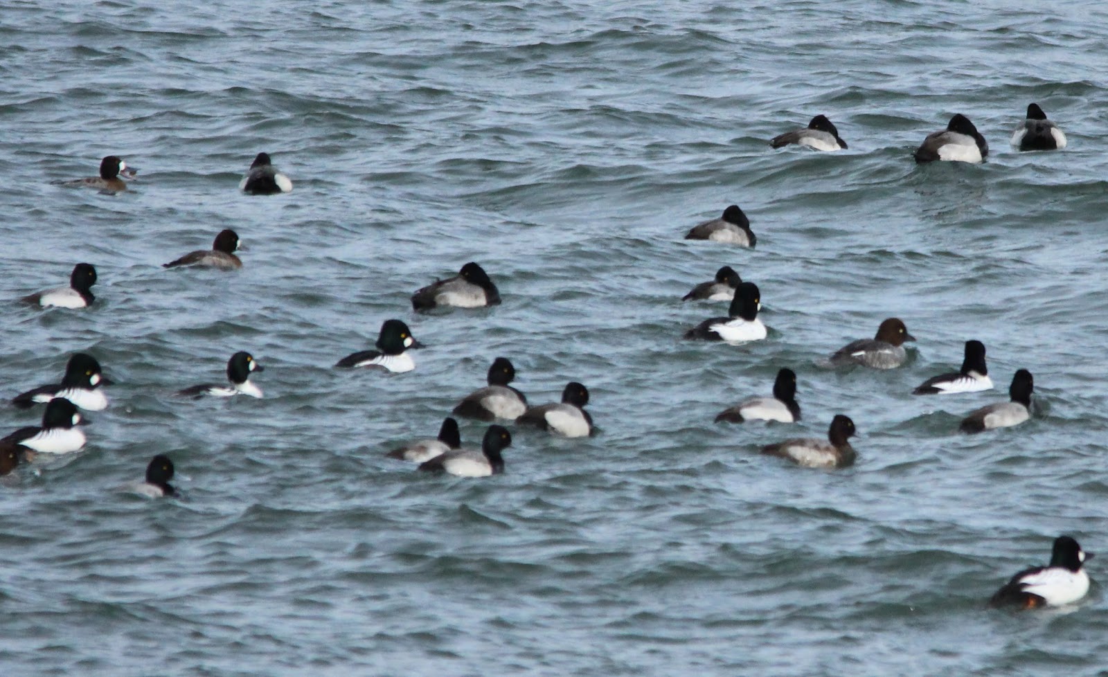
Here is a link to a short id article on scaup head shapes by Tony Leukering in the CFO publication.: SCAUP
Thanks for visiting.
No comments:
Post a Comment